
FAQs
- An active sporting reserve (the size of two Senior AFL sized sporting ovals)
- LED Sports Floodlighting
- A multi-purpose community sporting facility
- Car parking
- No flora of conservation significance was recorded during any of the field assessments, despite targeted surveys for Caladenia huegelil (Grand Spider Orchid)
- Outside of the degraded areas, the vegetation across the site is classified as Banksia Woodland which equates to approximately 140.42 hectares of area
- Presence of Quenda/Southern Brown Bandicoot diggings
- Evidence of Carnaby’s cockatoo foraging
- Based on the habitat present and current documented distribution of fauna, the following six conservation significant species are considered to possibly occur within or occasionally utilise Frankland Park:
- Carnaby cockatoo
- Red-tailed black cockatoo
- Quenda/Southern brown bandicoot
- Western brush wallaby
- Perth lined lerista
- Peregrine falcon
- No breeding, or potential breeding habitat or existing roosting trees were identified in field surveys.
- Clearly demarcate the area to ensure no vegetation is cleared outside the approved clearing area
- Conservation style fence will be erected to reduce impacts on or within the bushland area
- Grass trees or Zamia palms will be translocated to an appropriate area of Frankland Park or an appropriate alternate location within the City.
- A seed and plant collection will be taken for future revegetation programs within the City.
- A fauna relocation program will be implemented prior to clearing by a qualified zoologist.
- Clearing will also take place in an east to west fashion to allow any fauna to escape in to remnant bushland.
- Implementation of a feral management control program once clearing has been completed for the remainder of the reserve.
- Landscaping in the car park will utilise endemic vegetation
- Assorted nesting boxes will be placed by the City in areas not cleared
- Suspension of clearing in the event that Carnaby Cockatoo, Western Brush Wallaby or Quenda are sighted within the development area and not recommence until individuals have moved into adjacent habitat
- Begin works within two months of clearing to reduce degradation from wind erosion
- Maintain fencing around remnant bushland
- When nesting boxes are used, ensure evidence based specifications are implemented to prevent colonisation by European honey bees; and monitor and replace nesting boxes should be found
- Undertake disease (Phytophthora cinnamomi) hygiene measures prior to and during the clearing to prevent transmission into Frankland Park.
- Reducing the footprint of the overall site to minimise the need for any vegetation removal. The site has been positioned within degraded and/or poorer quality areas of vegetation (south-east corner).
- Identifying overall community needs based on consultation with key user groups, guidelines for standards of provision for different types of activities, analysis of demographics
- Existing site constraints, including topography, bush fire management, future road extensions, available service connections, interface with existing and future roads.
- Input from key consultant disciplines (architect, engineers etc)
- Overall available project budget.
- Rowley Road extension (under the control of Main Roads WA),
- Hammond Road extension,
- The current and future lane expansions along the Kwinana Freeway, and
- Other changes to the existing local road network immediately adjacent to the development site as a result of the future proposed roads being constructed.
Where will the proposed sporting reserve and multi-purpose community building be located?
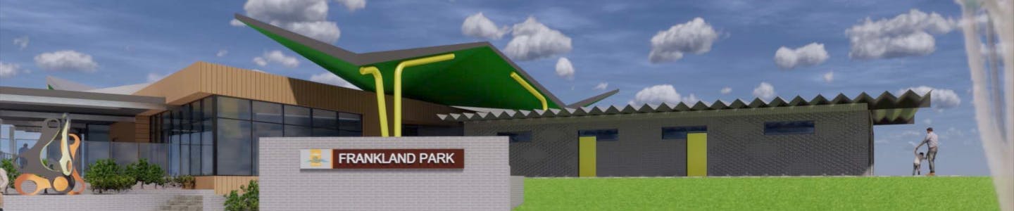
The new sporting reserve and multipurpose community sporting facility will be located in the south-eastern corner of Frankland Park. This section is mostly free of vegetation. Vegetation that is present in this particular section is mostly considered poor condition or degraded.
Frankland Park is located on Wattleup Road in Hammond Park on Lot 2022, which is owned by the State of Western Australia, vested to the City of Cockburn under management order.
The site is bound by Frankland Avenue to the east, Wattleup Road to the north, and further bushland to the south which falls within the City of Kwinana boundaries.
How was the location for the sporting reserve and multipurpose community sporting building chosen?
In September 2003 Council identified an area of Frankland Park be considered for active sporting facilities.
In May 2010, the Council adopted the City’s Sport and Recreation Strategic Plan 2009. The plan identified there was a shortage of active open space, particularly in forecast high growth areas such as Hammond Park. The development of new sporting facilities for junior and senior use was planned for construction in 2019.
In 2018, the City also renewed its long term facility plan, now called the Community, Sport and Recreation Facilities Plan. As part of this process, research and consultation highlighted the need for a reserve the size of two AFL ovals, with a clubroom, lighting and adequate parking in the south-east corridor of Cockburn. This project was therefore incorporated into the Community, Sport and Recreation Facility Plan and was adopted in 2018.
What is the project scope?
It is currently proposed that the project include:
What is an active sporting reserve?
An active sporting reserve is public open space with infrastructure suitable for organised sporting activities used by sporting clubs. This is opposed to passive reserves which enable everyday unorganised activities.
What will the indoor and outdoor spaces be used for?
Even though the outdoor space identifies as an active sporting reserve, it can also be used for general activities by the community. As such, it will be used by sporting clubs at certain times of the week but also can be used by people for general recreation purposes.
The indoor spaces again will have dedicated spaces for the sporting clubs; however there are two other spaces available for hire by the wider community. These spaces support groups who provide regular activities for the community (e.g. playgroups, pre-kindy, karate etc) and also larger functions and events (e.g. birthday parties, quiz nights etc)
What sports will be played at the reserve?
A publically open expression of interest process was conducted from May to June 2019 for summer sporting clubs to be located at the site once the project is completed in early to mid-2021. The submissions were assessed on merit and contribution to the wider community, with the successfully elected club being the Braves Baseball Club.
The Hammond Park Junior Football Club had already been identified as the primary winter sporting club at the site as they have currently out grown their existing location – Botany Park.
The reserve may be suitable for other formalised sports activities and can be hired when available through the City of Cockburn’s Recreation Services team. Casual activities can be played on the reserve when it is available without the requirement to book.
How does the draft design minimise environmental impacts?
The active sporting reserve and multipurpose community sporting building is proposed to be located in the south-eastern corner of Frankland Park. Most of this section is either not vegetated or classified as degraded or in poor condition.
The remainder of Frankland Park is predominantly covered with good quality native vegetation and the City intends to include remnant native bushland into its landscape design where possible.
Whilst the project is located in the mostly clear and degraded area in the south-eastern section of Frankland Park, some vegetation removal is unavoidable. Flora and fauna assessments were carried in both 2017 and 2018 as part of an environmental clearing approval processes to the Department of Environment (Federal Government) and Department of Water and Environmental Regulation (DWER - State Government).
Based on the flora and fauna assessment and consultation with the federal government, the City refined the concept plan to reduce the overall footprint of the development to preserve surrounding bushland; and to ensure that infrastructure is built within areas identified as being in poor condition or degraded.
Approval for a non-controlled action and to proceed to the State clearing permit process was granted by the Federal Government in April 2019 and a clearing permit by the State Government in March 2020 of a maximum of 2.4 hectares. .
What did the Flora and Fauna assessments identify?
Environmental Consultancy Focused Vision completed an assessment of the entire site of Frankland Park and identified the following:
To protect the site, the proposed footprint for the reserve has been significantly reduced and relocated to mostly cleared or degraded areas. Whilst a small portion of vegetation removal is required (2.4h), 1.42ha is classified as Banksia Woodland (TEC), with the remaining area is classified as degraded/significantly degraded.
How will the City manage flora and fauna?
Delivering projects with environmental care is a key priority for the City. The City will be adopting a number of mitigation strategies which have been developed with external consultant advice and the DWER.
Minimising impacts on flora and fauna is also a condition of clearing permits:
Are clearing offsets required?
Yes, as part of the clearing permit, the State Government has agreed as part of an overall offset package that Rose Shanks Reserve, Treeby be re-classified from ‘Parks and Recreation’ to the higher classification of ‘Conservation’. The site will remain that way in perpetuity to support the foraging habitat of the Carnaby Cockatoo.
Rose Shanks reserve is a 42 hectare site on the corner of Armadale and Warton Roads, which the majority of the site is Banskia Woodland (TEC) and like for like with Frankland Park. The offset package for Frankland Park is 9.9 hectares of the overall Rose Shanks Reserve site, with the remainder to be utilised by the City for future offset if required (subject to future detailed clearing applications).
What is the overall cost of the project?
A total budget of $9.3M has been allocated to the project, which is inclusive of $1.5M grant through the State Government’s Community Sport and Recreation Facilities Fund. Furthermore, this includes an allocation of claimable $4.62M from DCP13 (development contributions fund).
How did the City come up with the concept design?
The City has taken a variety of factors into consideration to develop the concept design. This includes (but is not limited to):
How can I gain future access to the community centre?
The proposed community sporting facility will be multi-purpose, with the intent to service the needs of the sporting user groups whilst also providing facilities that can be accessed by the wider community to deliver a wide range of different programs and activities.
Individual, clubs, organisations and/or businesses will be able to access the facility by making a booking through the City’s Recreation Services team through its regular facility hire processes and procedures, subject to availability.
Will there be sufficient parking?
The City is mindful to provide an adequate amount of parking for sports activities and community events. The City is planning to provide approximately 140 car parking bays at the site. Traffic and parking modelling is currently being undertaken and will be a requirement for the development application approval process.
How will security be managed?
The proposed facility will have a CCTV system that is integrated into the City’s wider CCTV network. The building will also have an access control and alarm system whereby use of the building has been granted by the City.
Furthermore, the building will be patrolled by CoSafe. CoSafe is the City’s safety and security service. CoSafe helps residents feel safer by providing an extra set of eyes and ears in the Cockburn community. CoSafe mobile patrols service all 22 suburbs in the City of Cockburn and visit all council facilities on their run sheet. CoSafe can attend to callouts and responds to alarms at council facilities, noise complaints, suspicious behaviour and anti-social behaviour. More information on this service can be found on the City’s website.
The City also has a Rangers Service which responds to any complaints against the Dog Act, Parking Laws, Off Road Vehicles, and specific local law breaches.
What is happening with the proposed Rowley Road extension?
The Minister for Planning has declared an approved planning control area over the proposed Rowley Road alignment between Kwinana Freeway and the Coast, which includes a portion of Frankland Park, located to the south of the reserve running east to west along the City of Kwinana boundary.
The Planning Control Area will protect the proposed transport access corridor of Rowley Road, between Kwinana Freeway and the coast. The Planning Control Area is created to ensure that no further development occurs on this property, which might compromise this purpose until it becomes reserved in the Metropolitan Region Scheme.
Visit the City’s website or visit the Department of Planning, Lands and Heritage for more information.
What are the timeframes for the residential development opposite Frankland Park?
The residential development opposite the proposed Frankland Park site on Frankland Road has been approved for subdivision by the West Australian Planning Commission, with works currently underway by the developer.
The sale of these lots once subdivision is complete will likely be dictated by market condition and population. The City has limited control over the timing of these developments.
When will the project be built?
Should the project proceed to existing timelines, the expected completion date is mid 2021.
Is traffic being considered as part of the overall project?
A Traffic Impact Assessment (TIA) will be undertaken as part of the project by a Traffic Consultant in accordance with the Western Australian Planning Commission (WAPC) TIA Guidelines for Individual Development – Volume 4.
The TIA aims to demonstrate that the proposal is consistent with the overall structure and subdivision planning in the area while also providing a greater level of technical details of any transport issues and impacts specific to the development and its immediate surrounds.
The assessment will also involve undertaking future forecasts and analysing aspects including but not limited to traffic generation by the project, integrating the development with the surrounding land uses and transport networks, addressing parking needs, providing high quality pedestrian and cycle networks both within the development and connected to the surrounding area, and ensuring adequate consideration is given to site access for all modes, that is, vehicle, public transport, pedestrian and cyclist.
Notably, the traffic assessment will also take into consideration a number of future proposed road improvements in the vicinity including:
It’s important to clarify that the above projects may be subject to approvals, funding further assessment.